'Most significant event in 50 years': a giant dust cloud moves over the USA
Air quality drops to dangerous levels as the largest dust cloud in several decades approaches the United States after a transatlantic journey, writes The Guardian.
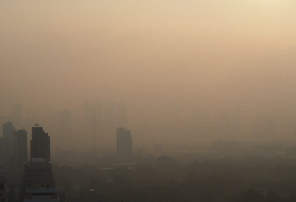
Photo: Shutterstock
A huge cloud of dust from the Sahara desert has already covered the Caribbean islands and is heading towards the United States with such dimensions and concentration that, according to experts, have not been observed for half a century.
Air quality in most of the region reached a record “dangerous” level, and experts who called the event “Godzilla's dust cloud” warned people to stay indoors and use air filters, if any.
“This is the most significant development in the last 50 years,” said Pablo Mendez Lazaro, an environmental health specialist at the University of Puerto Rico. “Conditions are dangerous on many Caribbean islands.”
Many health professionals are concerned about the health status of people struggling with coronavirus symptoms, since most of these symptoms are related to breathing. Lazaro, who is working with NASA to create a dust cloud warning system, said the concentration was so high in recent days that it could even have an adverse effect on healthy people.
During the cloud passage from Antigua to Trinidad and Tobago, extremely foggy conditions and limited visibility were recorded. Some people posted their photos on social networks in double masks to protect against coronavirus and dust, while others joked that the Caribbean looked like it was filmed on a video with a yellow filter.
On the subject: Air pollution kills 7 million people every year: where on the planet is it the cleanest
A mass of extremely dry and dusty air is known as the Saharan air layer and forms over the Sahara Desert. It crosses the North Atlantic every three to five days between late spring and early fall in the Northern Hemisphere, reaching its peak in late June to mid-August, according to the US National Oceanic and Atmospheric Administration. The layer could be 3 km thick, the agency reports.
Most of the dust of the first concentration reached Puerto Rico and the US Virgin Islands on Monday, June 22, not only clouding the sky, but also giving it a milky white tint. Visibility at the airport on Santa Cruz Island in the US Virgin Islands dropped to 3 miles (less than 5 km) and was limited to 5 miles (8 km) in San Juan, Puerto Rico.
On Tuesday, June 23, NOAA meteorologists posted on Twitter animated satellite images showing a huge dust trail moving across the Atlantic for five days. The images shown below were taken by the GOES-16 satellite.
#SATELLITE SPOTLIGHT: This #SaharanAirLayer (#SAL) tracking animation shows how the plume of #dust and #sand from the #SaharaDesert has moved westward over the last 5 days. Areas of red and pink represent the dry, dusty air as seen from @NOAA's #GOES16 ? ️ pic.twitter.com/mh7gULXFSU
— NOAA Satellites — Public Affairs (@NOAASatellitePA) June 23, 2020
The system is forecast to move northeast Thursday through Friday (June 25 and 26). More concentrated dust may fill the skies over East Texas on Friday, June 26, or Friday evening into Saturday, June 27. As in the Caribbean, dust is expected to cause reduced visibility and poor air quality from east Texas to Louisiana.
On the subject: American cities with the most polluted air
"Those sensitive to poor air quality should closely monitor local reports about it," said senior meteorologist AccuWeather and leading hurricane expert Dan Kottlowski. “Eventually, the dust will flow into other Gulf Coast states around the western and then northern periphery of the high pressure area in the northern Gulf of Mexico.”
"GODZILLA DUST CLOUD": A vast cloud of Sahara dust is blanketing the Caribbean as it heads to the US with a size and concentration that experts say hasn't been seen in half a century https://t.co/2tWQd0VFlV pic.twitter.com/WRvkarQZmJ
- ABC7 Eyewitness News (@ ABC7) June 23, 2020
Residents of southern Mississippi, Alabama, Georgia, and parts of Florida are likely to see foggy skies and face declining air quality over the coming weekend (August 27 and 28) and early next week.
According to Kottlowski, when dust moves west, part of it will precipitate or spread, becoming less concentrated. With reduced dust levels, the impact is likely to be less dramatic than in Puerto Rico.
“However, it will still be unusual and people will notice some haze and milky skies for much of Friday, Saturday and Sunday (June 26, 27 and 28) over East Texas,” Kottlowski said.
“Air quality could also drop to moderate to unhealthy this weekend due to dust in South and East Texas,” Kottlowski said. “Thus, people with breathing problems should not spend long periods of time outdoors. Some people with severe respiratory illness may simply want to stay indoors.”
Read also on ForumDaily:
A new storm has formed in the Atlantic Ocean and has already set a record
In California, a powerful earthquake occurred: tremors were felt from Sacramento to Los Angeles
7 states reported new hospital admissions record due to COVID-19
Subscribe to ForumDaily on Google NewsDo you want more important and interesting news about life in the USA and immigration to America? — support us donate! Also subscribe to our page Facebook. Select the “Priority in display” option and read us first. Also, don't forget to subscribe to our РєР ° РЅР ° Р »РІ Telegram and Instagram- there is a lot of interesting things there. And join thousands of readers ForumDaily New York — there you will find a lot of interesting and positive information about life in the metropolis.


-
Personal experience: who and why you should not move to the USA5614
-
50 diseases whose presence will increase the cost of health insurance in the USA4329
-
Great opportunities with ChatGPT: 12 easy ways to make money using artificial intelligence1324
-
What should not be on your resume if you want to find a job in the USA763
-
Four unforgivable mistakes immigrants make to the United States552
-
Dependence on cars and one supermarket per city: why ours is unusual in one-story America403
-
Ten secret restaurants in the USA: what is their highlight and how to find them254
-
Actions in a terrorist attack: how to survive yourself and help others6333
-
Personal experience: who and why you should not move to the USA5614
-
Where in the USA to buy the medicines we are used to: a list of pharmacies5330
-
How to hit the jackpot: tips from a man who won the lottery 7 times4898
-
50 diseases whose presence will increase the cost of health insurance in the USA4329
-
Life after death: what happens to places of mass executions in the USA3883
-
How to start a profitable business in the USA, if you have only $ 203281